


Maps Distance Calculator is an Android app designed to assist users in obtaining directions and calculating distances or areas on maps. By simply entering an address or selecting coordinates, the app automatically generates the best route and provides detailed navigation. Its intuitive interface and advanced GPS technology ensure a seamless experience for locating and tracking destinations in real time.
Powerful GPS Navigation and Real-Time Tracking
With Maps Distance Calculator, you can access voice navigation for step-by-step guidance to your destination while viewing your current location on the map. The app uses GPS to track your movements in real time, enabling hassle-free walking, driving, or cycling directions. Integrated map options, including hybrid, terrain, satellite, and normal views, enhance flexibility for various needs.
Distance, Area, and Land Calculations Made Easy
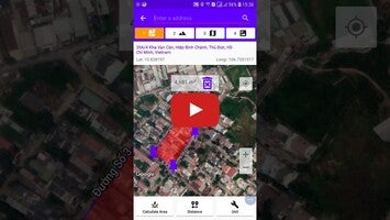
The app offers precise measurements for distances, perimeter, and land areas, making it highly versatile for users who need detailed geographic calculations. By selecting at least three points on the map, you can calculate areas and explore land-based measurements using supported units like kilometers, meters, and feet.
Additional Features for Enhanced Usability
Maps Distance Calculator also includes features such as a compass for orientation, tools for saving and sharing locations, and social network compatibility for sharing details via email or messenger apps. It ensures convenience with functionalities like real-time address tracking and the ability to save or share GPS coordinates.
Maps Distance Calculator provides a comprehensive solution for navigation, measurement, and land exploration while delivering accurate results and reliable performance for diverse user requirements.
Requirements (Latest version)
- Android 4.1, 4.1.1 or higher required
Comments
There are no opinions about Maps Distance Calculator yet. Be the first! Comment